

Accepted data types
Boundary files (KML/KMZ, .shp)
-
Visualize data such as zip codes, disaster zones, business territories and much more with support for KML/KMZ and .shp file formats.
Marker files (.csv)
-
Upload thousands of markers instantly to quickly identify your areas of interest.
Uploading a file
In this example we will upload a marker file using the My Data manager within Population Explorer's interface.
The steps in this process are identical to those required to upload a boundary file.

Open the My Data manager
-
Expand the "My Data" section of the PopEx side menu.
-
Select "Marker files" > "Upload Marker file."
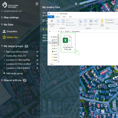
Choose a file to upload
-
Select the maker file you would like to upload to Population Explorer. [NOTE: the file must be preformatted to include column headers titled: Name, Latitude, Longitude, Description]
-
After a file is selected you will have the ability to complete the process by selecting "Upload."
Using your uploaded files

Select a file
-
Create or choose a Target Group and select the "My Marker files" item from the Add Item menu.
-
Select the marker file you would like to use.

That's it!
You can now select the markers you would like to visualize on the map. You can then use them to define catchment areas and create boundaries (e.g., reference the centerpoint of a buffer).
The process illustrated in the steps above for uploading a marker file, apply when uploading shapefiles as well.
If you experience any issues with this process, feel free to schedule a demo with us or contact PopEx Support.

Troubleshooting
The most common issue users will face when uploading marker and boundary files result from incorrect formatting. Follow the guidelines for each format below to avoid receiving an upload error in Population Explorer.
.shp format (also known as ESRI shapefile format)
-
Uploaded file must be zipped and include the following file types inside: DBF, PRJ, SHP, and SHX. (see image on left)
.kml or .kmz format (our suggested boundary file type)
-
These files are commonly used by mapping resources such as Google and are simple to use and upload. These are standalone files and do not need to be zipped.
.csv format (marker files only)
-
The Excel spreadsheet should include ONLY the four following column headers: Name, Latitude, Longitude, Description. The headers are format dependent so make sure the first letter is capitalized and spelling is correct.